
Overview
Bearing a resemblance of knuckles of a clenched fist, the Knuckles Mountain Range located in the districts of Matale and Kandy, has been declared as a conservation area and features 34 peaks. This area is also referred to as the Knuckles National Heritage and Wilderness Area. It is important to note that it is also a UNESCO World Heritage Site. Spanning over an area of 155 square kilometers, its highest point is approximately 6000 feet above sea level. This mountain range is a popular attraction among adventure lovers as well as nature lovers and is a main eco-tourism spot in the country. While the name Knuckles was appropriately given by the British, locals prefer to call the area as Dumbara Kanduvetiya, which means Mist-laden mountain range. Kirigalpoththa, Gombaniya, Knuckles, Koboneelagala and Dotulugala are the names of the five peaks.
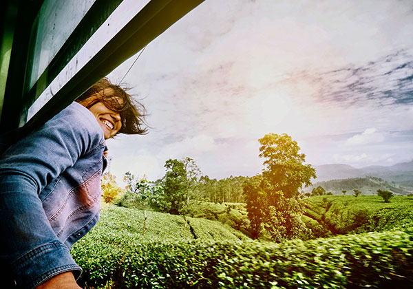
There are five major forest formations and this mountain range is home to a wide diversity of flora and fauna; which include a few exceptional species. This mountain range is home to over 40 rural villages and borders both the dry and wet zones. No matter the time of year, there is always a thick mist around the mountains. The unpredictable and constantly changing climate here along with heavy rains and leeches may make trekking seem like an arduous task. For the adventure lovers and nature lovers who are up for a challenge, a trek is the perfect way to explore this mountain range. There are a few different trails leading to the Knuckles Massif, offering stunning vistas and the unparalleled opportunity of witnessing the lush greenery of the hill country.
Four of the most popular and often travelled trails are; the trail to Mini World’s End from Deanston, trail from Deanston to Dothalugala, trail from Corbet’s Gap to Nitro Caves, trail to Augallena cave via Thangappuwa from Corbet’s Gap and finally the trail from Meemure to Kalupahana. The stunning cascading waterfalls and streams and flora and fauna that can be spotted along the way makes Knuckles a hiker’s haven.
The vegetation changes throughout the way and the valleys consist of large trees and semi green vegetation. Tropical montane evergreen forests can be found in the upper slopes while the upper levels consist of cloud forests. The ‘Pitawala Patana’; a beautiful grassland is also a unique sight to see. The Knuckles Mountain Range is an important conservation spot for montane tropical forest habitats in the South Asian region. The Dumbara Valley sets apart the Knuckles massif from the central hills. About 1033 floral species have been identified along with 128 bird species (The Black Eagle, Barbets, Pale Billed Flower Pecker, Lorikeets, Herons, Egrets, Bulbuls, Babblers, Woodpeckers and Kingfishers), 31 species of mammals (such as the Wild Boar, Sambar deer, Elephant, Wild Buffalo, Monkey, Loris, Jackal, etc.), 20 amphibian species, 15 fish species, 60 butterfly species, 17 mollusks species and 53 reptile species. The existence of a wide variety of birds make Knuckles a fitting spot for bird watching.
A noteworthy feature of the Knuckles massif is that it represents nearly all of the major climatic zones in the country. It is an all- year round destination. In spite of that, the dry season (from June to September) is the best time to visit. En route to Knuckles, make sure to stop by Meemure; a small village with sceneries that are bound to enthrall you, and the Mini World’s End.
History
Taking its name from a string of recumbent folds bearing a resemblance to the knuckles of a clenched fist, the Knuckles Mountain Range was named so by British surveyors. This area, also referred to as the Dumbara Kanduvetiya (mist laden mountain range) has a rich historical background. It has been stated that in ancient times Knuckles was called Giri Divayina and Malaya Rata. Archaeological proof indicates that this has been a settlement of the Yakshas in ancient times.
How To Get There
There are various modes of travel in order to arrive at Knuckles, located in central Sri Lanka, from the metropolis of Colombo.
By road: when travelling by road, you could either self-drive or taxi. This is an unrushed and comfortable mode of travel. The best way to arrive at Knuckles from Colombo is via the Colombo- Kandy Road (A1). Traveling on this route would only take 4 hours and 15 minutes. An alternative option would be to take the A10 route and this would take approximately 4 and a half hours. Another possible route to take is via the Talgodapitiya- Yatawatta- Dombawela Road (B409).
By bus: travelling by bus can be a bit tiring at times, however it is an economical mode of travel. Once you board the bus from Colombo, it will take just over three hours to arrive in Kandy; the time duration may vary depending on traffic conditions along the way. From Kandy the best option would be to taxi to the Knuckles massif. This journey covering an approximate distance of 40 kilometers will take nearly two hours.
By train: traveling by train, which is also a public mode of transport, is also an economical and uncomplicated mode of travel. Since the final destination is Knuckles, the most suitable option would be to board a train leaving the station at Colombo Fort to Polgahawela. This train journey takes just over two hours and the train makes short stops en route. After getting down from the railway station at Polgahawela, the next option is to taxi the rest of the way. This will take approximately 3 hours and 15 minutes.
By air: even though traveling by air can be quite an expensive mode of travel, it is the most relaxed and fastest way to arrive at your desired destination. Since there aren’t any direct flights to Knuckles the ideal choice would be to fly to Katugastota from Diyawanna Oya in Colombo. The journey will take only 30 minutes. From Katugastota, you will have to taxi the rest of the way to the Knuckles Mountain Range.
From Nuwara Eliya: in order to arrive at Knuckles from Nuwara Eliya there are a very limited set of options to choose from; you could either drive or taxi. The time duration of the journey will take just over 4 hours and may vary according to traffic conditions. The best route is via Mahaweli Raja Mawatha (B492). You could also travel via the A5 or the Awissawella – Hatton- Nuwara Eliya Highway (A7).
From Batticaloa: if you wish to reach the Knuckles Massif from Batticaloa, you could either travel by road, by air and by train. Traveling by road via the PBC highway (A5) and the Kandy- Mahiyangana- Padiyatalawa highway (A26) will take just over 5 hours and timing may vary depending on traffic. An alternative route when traveling by road is via Mahiyangana- Dimbulagala- Dalukkanne Highway. If you opt for a more economical mode of travel, such as traveling by train, the best option would be to catch a train bound to Kurunegala before taxiing the rest of the way to Knuckles. The entire journey will take approximately 9 and half hours. You could also fly to Katugastota from Batticaloa before taxiing the short distance to Knuckles.
Vehicle and taxi arrangements or flight bookings can be made for you by our tour consultants at Epic Sri Lanka Holidays.
Climate
The weather at Knuckles is highly unpredictable and there is a possibility of raining suddenly without warning. The best period to visit this massif is between the months of June to September since there is a lesser probability of rain. March to May is also a good time for a trek because the possibility of rain is low. The temperature at Knuckles varies between 5.5 degree Celsius and 35 degree Celsius with an average rainfall ranging between 3000- 5000 mm. Visitors should be aware of the thick fog that can cover up the whole area in just a few minutes.
Food and Drink
There are a plethora of cafes and restaurants in the vicinity of the Knuckles Massif ranging from street eats to fine dining. Some such restaurants with delicious food and excellent tourist reviews are ‘The Spicy Kitchen’, ‘Amanda Rest’, ‘Mama’s Kitchen’, ‘Sangraha Restaurant’, ‘Ape Bojun Plus’ and ‘Burger Inn’. Satisfy your food cravings at these restaurants before embarking on a trek or hike to the Knuckles Mountain Range.
Knuckles Highlights
Hiking and Trekking in the Knuckles Range: the Knuckles Mountain Range consists of some of the most heavenly nature trails in Sri Lanka. Trekking the Knuckles Mountain Range may be a bit of an arduous task because of the thick fog, unpredictable weather and the large leech population. In spite of all these trekking the Knuckles Mountain Range will prove to be an unforgettable experience. Ergo, it is one of the best places for a backpacking escapade. There are a great many mountain trails which offer trekkers to trek across waterfalls, dense forests, etc. There are a few options to choose from when hiking; you could either stick to a one day hike or spend the night camping under the stars. The more adventurous souls and the more committed and experienced trekkers can even take on a three day hike accompanied with a guide who has knowledge regarding the area.
Pitawala Pathana: this grassland is located within the Knuckles Mountain Range and is situated along the Rattota- Illukkumbura road; in close proximity to Riverstone. It spreads out over an expanse of about 10 hectares of a gently sloping slab of rock. The Pitawala Pathana ends in a steep cliff which is similar to the world renowned World’s End in Horton Plains and is known as the Mini World’s End.
Mini World’s End: the Mini World’s End is a spectacular observation point located within the Knuckles Mountain Range. It is an escarpment with a sheer drop of 1192 meters. At this point you are met with magnificent and panoramic views of the surrounding. Deanston, which is the starting point for the hike to Mini World’s End, is an off beaten hiking path.
Meemure: situated in the vicinity of the border between the Kandy and Matale districts, Meemure is a small, isolated village with a population of about 400, tucked away in the Knuckles Mountain Range. Located 50 kilometers away from the ancient city of Kandy, it is accessible only through Hunnasgiriya. While the view is pretty and stunning, the trail from Hunnasgiriya to Meemure can be a bit problematic at times. If you wish to alienate yourself for a few days or just a few hours, then Meemure is the place to be since there are no signals from mobile networks or direct mail delivery. The pyramid shaped mountain of Lakegala, Ravana Falls and the village of Gala Muduna are nearby attractions.
Mini World’s End: The Mini World’s End at Deanston is a spectacular view point located within the Knuckles Mountain Range. An escarpment with a sheer drop of 1192 metres, it gives magnificent and panoramic views of the surrounding misty landscapes.
Riverstone: located nearly 30 kilometers away from the city of Matale, is the Riverstone peak. The road that leads up to this peak is secluded, long and winding with magnificent views of the surrounding area. On the way to the top, waterfalls such as Sera Ella and Bambarakiri Ella can be seen. The trek to the top of the peak cuts across the Pitawala Pathana and offers stunning views of the Knuckles Mountain Range and the Thelgamuwa Valley.
Sembuwatta Lake: the Sembuwatta Lake is a man- made lake situated in Elkaduwa, within the district of Matale. The water in the lake is natural spring water and there is a swimming pool alongside the lake itself. This lake is a property of the Elkaduwa Plantations and attracts many visitors with its beauty. The road leading up to the Sembuwatta Lake is narrow with a lot of bends and is not in very good conditions. Therefore it is best to go up to the lake in a trishaw.
Aluvihare Cave Temple: this historically important Matale Aluviharaya, encircled by hills, dates back to the 3rd century B.C, to the time of King Devanampiyatissa. It is highly important because this is where the Pali Canon/ Tripitaka (a standard compilation of scriptures in the Theravada Buddhist tradition) was first written down during the time of King Walagamba. Before this the Tripitakas were passed down by memory and was never written down. The Tripitakas are grouped into three divisions (Vinaya Pitaka, Sutta Pitaka and Abidhamma Pitaka) Many Buddha statues in seated, recumbent and standing positions along with murals that display Jataka stories can be seen on the walls of this rock temple.
Corbett’s Gap : Corbett’s Gap, a famous attraction and a popular viewpoint of the Knuckles Mountain Range. It is part of one of the trekking trails that originates from Hunnasgiriya. It is a deep valley and also happens to be a rain shadow area. The vegetation here can vary between wet, dry and montane vegetation.
Waterfall Hopping: The Knuckles Mountain Range, being one of the most beautiful and scenic places in Sri Lanka, is home to plenty of waterfalls that would encourage one to spend a day trekking and waterfall hopping.